|
 |
|||||||||||||||
|
|
The railways in the region, a brief look in history. Already in 1816, before the independence of Belgium, just after the fall of Napoleon, there were first ideas of making a Belgian Railway. Thomas Gray and John Cockerill had the idea to devellop a railway (animal traction) for the transport of coal between Belgium and the Netherlands. In the beginning of 1830, some railways (animal traction) were build in the backyard of the coalmines or between the coalmine and the nearest channel. (Bois du Luc, Grand Hornu, Haut and Bas Flénu…). In 1835 horse traction was replaced by machines. The 5th mai 1835, Belgium had it's first public railway between Brussels and Mechelen. Steamtrains were used. The first public railway in Great Brittain was in 1825. Still we had to wait for Germany till 7 december 1835. France had it's track in 1837 and in 1839 the United States and Italy followed. Starting in 1835 the Belgian gouvernement made a study if it would be possible to give the region between Sambre and Meuse a steamtrain railway. This region was rich on raw material, slate quarries, saw-mills and had metallurgical industry. A steamtrain track would make it easy to transport all the goods to Charleroi. In 1845 a limited liability company was founded: "Chemin de fer l'Entre Sambre et Meuse" (Railway between Sambre and Meuse). It was a Brittish company (W. P. Richards Co.) who had the contract to build and exploit the railway in this region. Rapidly new tracks were build after the opening. Several lines were opened: Charleroi – Walcourt
27 november 1848 The section which interests us most directly: Mariembourg - Vireux. In Vireux, a listed line 148 (Brussels - Charleville) joined the French network. In 1854, the track between Sambre and Meuse merged with
the track Antwerp - Rotterdam. This unity was called "Grand Central Belge".
On the 1st of january 1897, the line Mariembourg - Vireux was taken by
the Belgian State. Because Vireux was in France, a borderstation was build in Vierves on grounds offered by the earl of Vierves. Treignes only had a stopping place. Only later a borderstation was build in 1902. Because more and more trains were comming there, it became bigger and bigger. In the past the station had 7 railtracks and a turn-table. The building is still today very impressive with it's two high parts. On the first floor appartments and downstairs a custom house. It's the widness of these precious times. In 1925, the Belgian railways wanted to double the railtrack between Mariembourg and Treignes. Today you still can see some bizarre spots like the bridge next to railway crossing at Olloy and the beginning of the perforation of the tunnel at Abannets. Nowadays nature has reclamed its rights and covers the entrance with vegetation. The track we use is called track 132
in the archives of the SNCB, the track was used until 29 september
1963 for public use. The transportation of goods on the part Mariembourg – Nismes
was eliminated on 12 october 1977. Only the part Mariembourg – Nismes
had double tracks. From Mariembourg to Treignes – track 132 D. Track 132, Mariembourg - Treignes
goes trough the valleys of "La Brouffe", "l’Eau
Blanche", "l’Eau
Noire" and " Viroin". The name « Three Valleys» comes
from the last 3 rivers. The railway goes trough following villages
: Nismes, Olloy sur Viroin, Vierves and Treignes. The Fagne (Don't confuse with "les Hautes Fagnes") is a great clay sinking with slate underneath. This region has a low population density and is covered with woods and prairies. Mariembourg is situated in this region. The Calestienne is the region crossed by the track between Mariembourg and Olloy. Between Olloy and Treignes, you can see the Calestienne on your left site. The characteristics of this region are a succession of lime ridges and valleys rich of silt. The hills remained stripped until the beginning of the XXnd century, they were reserved as meadow for the goats and sheep. The nature of the ground and the orientation of the hillsides make it possible to observe a hot and dry microclimate. A particularly rich flora and fauna can be found here. Moreover, the calcareous nature of the ground makes it possible to observe many collapses and the presence of several caves. These caves allowed the habitation since the ancient times. In the valleys, cereal agriculture developed. Last comment, the presence of iron ore made it possible to develop the iron and steel industry. The Ardenne. The solid ardennes massif is present here, in the south of the Meuse. The first buttresses are visible in the south of the line starting from Olloy sur Viroin. (On the right while going towards Treignes). The important forest solid mass, primarily of the leafy trees, represents and represented an important activity for the area. The exploitation of the forest solid mass brought to the inhabitants a whole series of activities related to wood (Wood of furnishing, frame, heating, of mine, clog factories, cooperage, charcoal....) If one observes a little bit the area and if you put it in a broader context, we can observe that the zone of the l'Eau Blanche and the Viroin constitutes an economic axis which was important a few decades ago. Not only of the important richness was exploited, but moreover the valleys allowed the evacuation of it. Nothing astonishing thus so that the railroad settles and gives a great economic advancement to the area. The richnesses being is exhausted or regarded as economically nonprofitable; the rail transport was abandoned. This corridor of communication in addition caused certain covetousnesses. Thus during war 14-18, the railway line allowed an easy communication towards Charleville and Verdun...
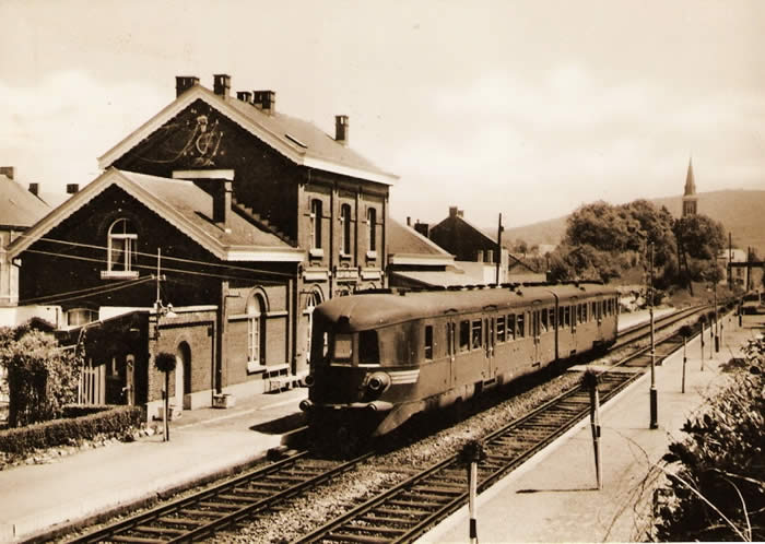
Mariembourg. In 1546, under the reign of Marie of Hungary, sister of Charles Quint, a fortress is set up which takes the name of Mariembourg. This fortress of plain protected the south from the Netherlands of Charles the Fifth of France. Marie of Hungary chooses the ground of Vérofle to realise her project of construction. These grounds belonged, as of the IXe century to various religious communities; abbey of Lobbes, principality of Liege, brood of Norbertines (Floreffe). In 1554, the fortress was conquered by Henri II of France and was restored in 1559. In 1659 Mariembourg becomes French again (Louis XIV - treaty of the Pyrenees) in 1815 to be included with the Kingdom of the Netherlands. Belgian independence in 1830 restored the places for the Kingdom of Belgium. Small anecdote, did you know that Mariembourg was the last Belgian city under Napoleonean administration after the battle of Waterloo and that Givet, which is located a few kilometers away (in France), resisted some time after the abdication of Napoleon?
With the visit of Louis XIV in the city, there remains a typical piece of music, the swing of Mariembourg or dance of the bouquet, carried out in 1692. During the long French period (1659 - 1825), Mariembourg provided a number of soldiers, and the Napoleonean time is still present in the memories. In 1830, after the departure of the Dutch troops, the population would have liked being a part of France. The fortifications were dismantled in 1855 (Convention of the fortresses - London 1831). The development of the city was supported by the creation of the railroad and the dismantling of the fortifications. Nearly 200 railwaymen lived in the city with the apogee of the rail and the habitat extended, being more enclosed in the yoke of the fortifications. The station was an important junction of railways, it assembled five lines, towards Charleroi, Hastière, Vireux (Reims - Charleville), Couvin and Chimay (Momignies - Anor). Today, the "RAVEL" replaced the railway line connecting Mariembourg to Hastière. It is tourism which makes the city live today .... The installations of the CFV3V are completely separated from those of the SNCB. Indeed, the difference in regulation does not authorize a common exploitation on the site of the SNCB. The installations of the CFV3V are easily accessible by foot from the SNCB station... but don’t follow the railtrack! The deposit of Mariembourg (LMG) is built out of red bricks, the roof being out of concrete. The architecture of the deposit is rather particular, just like in Florennes, the building is in rotunda. The rotunda of Mariembourg is the last in service and it shelters a part of the material of the association. Originally, 6 railtracks were in this building. Currently, 5 tracks are in service. Under track 2, we find a pit which must allow the inspection and the maintenance of the machines. The rotunda was never served by a turntable. Triple switches make it possible to reach the various railtracks. On the site, we find, in service, a water tower and a water crane which
are used for the provisioning of the steam engines. Next to the water
crane, a second inspection pit can be found. The departure of the train is from one of the platforms. On the site, to finish, we find the reception building. A great parking place for visitors can be found at the back of the rotunda, near the water tower.
This first section of the course is rather short. The first road that we cross carries out to the RAVel track. The latter carries out to Hastière on the site of the old railroad. We cross the Fagne and the first meadow on the right names the "Meadow of the Huts". In XVIème century, an epidemic of plague devastated the area and it is in this place that the huts intended for the patients were built. Here also, the corpses were cremated. From this period we go back to the worship Saint Roch, very present in the area. The tradition wants that Saint Roch looks after the patients until he catches their plague. He isolated himself in the forest, a dog came to supply him, an angel came to look after him and cures the saint. This history explains why, in all the area the worship of Saint Roch is still living and there are many little chapels where the saint is represented, accompanied by his dog. Let us be lenient, we find the same legend elsewhere and more particularly in France. The railroad crosses perpendicularly the calcareous grounds by going right towards the hill of the “Rock à Lomme”. At the foot of this rock the l'Eau Noire (Black Water) and the l'Eau Blanche (White Water) meet each other to form the Viroin river. A little further, we arrive at Nismes, first station. On the left side of the track we find the "Mountain of the Boxwood". It acts as one of the first natural reserves created by Ardenne and Gaume in October 1947. These boxwood solid masses (buxaie), which develop on the limestones slopes, are characteristic for the vegetation of the area. This plant sub meditarian benefits from an excellent exposure to the sun finds here its establishment most septentrional. The boxwood combined with the oaks and form at certain places an excessively dense thickness. In the dry lawns, one finds a rare flower immortalized by the famous Belgian painter Redouté (born in Saint Hubert in 1759), the pink pimpernel also named the "rose tree of Mariembourg".
Nismes.
The station of Nismes was built in 1868. This superb
gray stone building of the country is located a little apart from the
village. The building of the station became a private housing. At the
beginning, the road of Dourbes did not cut the platform.... The protection
of the PN (level crossing) had not to be ensured by a member holding
up a disc 21 (prohibition to cross) like currently!
The first historical information of which we can be certain goes up to the Xth century, Nismes belonged to the abbey of Saint Germain des Prés. The king of France, Robert the Piles received this abbey, the grounds of Nismes (like those of Boussu, Couvin, Pesche and Frasnes). Thereafter, he gave the grounds to his sister Hedwige, which married Régnier IV of Hainaut. In 1096, Baudouin II of Hainaut sold these grounds to the episcopate of Liege. During more than 3000 years, the prosperity of the country is related to the iron and steel industry. Indeed, the iron ore is present and the forests abound. The iron and steel industry made fortune in the XVIII and XIXth centuries of the Licot family. Their castle, old convent cistercian, transformed, is today the seat of the municipal authorities of Viroinval. The foundry was located at the bottom of the park of the castle and used the ore extracted from Abannets and Fondrys. The foundries also used many waste of the foundries of the gallo Roman time. This raw material was called "buckwheat Crayats". The nickname of Crayats designated a long time in the popular speech of the inhabitants of Nismes. With the decline of the low hearths, the crayats are dispatched towards the forging mills of Providence in Charleroi, who’s Mr. Licot was one of the founders. The site of the low hearths was transformed into sawmill, still active today. At the beginning of the XXth century, the clog industry developed in Nismes. In Nismes, it is advisable to visit the farm of Maladrerie, place where in 1527 the people with the plague were treated (Try Saint Roch) as well as the House of the Baillis. Another attraction, “Fondry aux chiens”,
spectacular site of an old exploitation of extraction of the iron ore.
From Nismes to Olloy sur Viroin. Here we are in the valley of Viroin and we will remain in it till the end of the railway in Treignes. Soon after having left the station of Nismes, we notice impressive industrial buildings, it's the old tannery of Houbon. We find ourselves at the foot of the Roche à Lomme. The tannery of which the buildings will be restorated (there are plans to make 16 apartments in there) culminated in the XIX century. Tanning, an extract of the bark of the oak-tree, which there were a lot of in this region at that time .
"Roche à Lomme" or sometimes wrongly spelled as "Roche à l'Homme" makes people think of a legend of a rider falling from his horse. Nothing of the sort, the rock named like this was just a boundary-stone for the south of "Pagus Lommensis". This land got its name from the river Lomme, a tributary to the Lesse. The river constitutes the north-east border of this land. At the very top of the rock you have a splendid view over the whole region. The summit with its standing cross was occupied since the neolithic time. A square tower of roman origin inclined for a long time the spot. A roman garrison guarded the road coming from Saint Quentin and crossing the Sambre and Meuse. Soon after the tannery, the railway enters the tunnel of Abannets which is about 500 meters long. The Viroin revolves the boulder and finds the railway at the exit. The name "Abannets" is derived from the obsolete word "abannir"= "to forbid". A decree of the bishop of Liege forbidded to have cattle graze in these areas full of truffle holes. One of the most popular Abannets is the "Fondry aux chiens" After the tunnel we find at our left a very important quarry. The exploitations
destined for extracting schist, sandstone or calcareous were very numerous
in this region. Most of the houses were built out of landstones (grey
and sometimes pink). A lot of the quarries were exploited just to build
local homes.
Olloy sur Viroin.
The station of Olloy is the property of the municipal
administratives of Viroinval.
The building is fully restored in 2014. The station was built in 1901, constructed with red bricks and with a magnificant roof in glass to protect the travellers of platform 1 against bad weather. When the SNCB managed the line it won for several years a contest for the most beautiful flowered station. It was also used for many times as a film scenery. Several episodes of the film "Maigret" were shooted at this station. At the exit of the station a relative old signal is these days still working. In 1909, a local railway permitted to reunite Olloy with Oignies. So the Olloy station made it possible for travellers and goods (as schist, sandstones and wood) to get connection between the railways of the SNCB and SNCV. In 2004 the municipal territory was excavated and a protohistorical fortification was updated (Celtic period). Olloy became part of the manor of Liege, the vasal of the dukedom of Bouillon and the principality of Liege. For a long time the iron-foundry and quarries gave work to the inhabitants. Today they are living from tourism.
From Olloy sur Viroin to Vierves. Leaving the station, the railway is infiltrating the centre of the town, between the houses, next to the church which was recently reconstructed, so to finally reach the foot of the Rolinveaux hill. From Mariembourg to Treignes, the railway is continually descending, except at the hill. At the summit of this little steep path we find an optional stop at the level of a hotel-restaurant(just shake the red drape tightened in the fence).
Vierves.
From Vierves to Treignes. The railway is twisting along the Viroin river in a beautiful valley, we are approaching the end of our traject.
Treignes. Treignes is called "the town of musea". - the museum of agricultural machinery - the museum "malgré tout"= "despite of everything "
Next
to these musea you can also visit the ruins of a gallic-roman villa,
but the town became mainly known through the person Toine Cullot, the
mayor of Trignolles, created by Arthur Masson. In the main street of
the town, a place is dedicated to this person from Walloonie. The
novel of Arthur Masson, "Thanasse and Casimir" is put in scene.
The station of Treignes. The station was acquired in 1972
by the University of Brussels to set up a laboratory for the study
of the fauna of the region.
We have described the building earlier in this brochure.
As the station was used as border station
you can still find wooden watch-towers, they helped the custom house
officer to survey and inspect the goods-train. It is no coincidence that one of the musea is called "Musée de Malgré-Tout"(despite of everything). This museum is located a few hundred meters from the train station.
This is where the new acquiries of the
association are restored en serviced. Thanks to the members of the CFV3V and the Formation
Centre of Treignes (CFT) we can work on engines, rail cars, wagons, etc.
on the two tracks(45 metres each) and a pit of visit installed for this purpose.
On the site of Treignes, there are some interresting discoveries to make. In front of the station, at the back of the site there is a turning table. It's working on manpower, you could say that the volonteers to make it turn are not legion. For the curious amongst us, in the slide of the bridge you can find traces of a machine-gun from Worldwar 2. Also at the back there is a typical water tower which is not standing at the CFV3V site, but it's a part of the surroundings of the railway. At the entrance of the site, there is a controlcabinet that made it possible to serve the railway-switches. There are also 2 fundamental signals and a waterhoisting crane(on the guay) which is not connected. Next to the crane there is the old building of the lampchamber lodging, today certain pieces belonging to the rural life museum are there. This is where the track ends after 14 km. Not far after the bridge over the Viroin, the track goes into France where it is derailed. In old times this track went through the tunnel of Najauge which is now used to grow mushrooms... |
|||||||||||||||
 |
 |
 |